普拉特河
| 普拉特河 Platte River | |
Nebraska River[1], Shallow River[1] | |
 普拉特河一景,位于马奥尼州立公园 | |
| 国家 | |
|---|---|
| 省/州/邦 | |
| 地区 | 北美大平原 |
| 屬於 | 密苏里河流域 |
支流 | |
| - 左侧支流 | 北普拉特河、卢普河 |
| - 右侧支流 | 南普拉特河 |
| 城市 | 北普拉特、卡尼、格蘭德艾蘭、弗里蒙特、奥马哈 |
| 主源 | 北普拉特河 |
| - 位置 | 科羅拉多州杰克逊县Confluence of Grizzly Creek and Little Grizzly Creek |
| - 海拔 | 8,050 ft(2,454 m) |
| - 坐标 | 40°38′23″N 106°24′19″W / 40.63972°N 106.40528°W / 40.63972; -106.40528 [2] |
| 次源 | 南普拉特河 |
| - 位置 | 科羅拉多州帕克縣Confluence of Middle Fork and South Fork South Platte Rivers |
| - 海拔 | 8,785 ft(2,678 m) |
| - 坐标 | 39°00′40″N 105°44′25″W / 39.01111°N 105.74028°W / 39.01111; -105.74028 [3] |
| 汇合点 | |
| - 位置 | 內布拉斯加州林肯縣北普拉特附近 |
| - 海拔 | 2,762 ft(842 m)[2] |
| - 坐标 | 41°06′50″N 100°40′33″W / 41.11389°N 100.67583°W / 41.11389; -100.67583 [1] |
| 河口 | 密苏里河 |
| - 位置 | 內布拉斯加州卡斯縣与薩皮縣的普拉茨茅斯 |
| - 海拔 | 942 ft(287 m)[1] |
| - 坐标 | 41°03′14″N 95°52′53″W / 41.05389°N 95.88139°W / 41.05389; -95.88139 [1] |
| 长度 | 310 mi(499 km), West-east |
| 流域面积 | 84,910 mi²(219,916 km²)[4] |
| 流量 | 路易斯维尔,河口上游约10英里(16公里)。 |
| - 平均流量 | 7,037 ft³/s(199 m³/s)[5] |
| - 最大流量 | 160,000 ft³/s(4,531 m³/s) |
| - 最小流量 | 131 ft³/s(4 m³/s) |
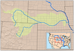
 绿色为普拉特河流域,包括南北两大支流。 | |
 普拉特河及其支流,所经湖泊与城市 | |
普拉特河(英语:Platte River、/plæt/)是内布拉斯加州的一条主要河流,长约500公里,由北普拉特河和南普拉特河汇合而成。
目录
1 另见
2 参考文献
3 延伸阅读
4 外部链接
另见
- 内布拉斯加州河流列表
- Morning Star Lake (Nebraska)
- 普拉特河州立公园
参考文献
^ 1.01.11.21.31.4 Platte River. 美国地质局地理名称信息系统. [2010-10-03].
^ 2.02.1 North Platte River. 美国地质局地理名称信息系统. [2010-10-03].
^ South Platte River. 美国地质局地理名称信息系统. [2010-10-03].
^ Boundary Descriptions and Names of Regions, Subregions, Accounting Units and Cataloging Units. U.S. Geological Survey. [2010-10-03].
^ USGS Gage #06801000 on the Platte River near Louisville, Nebraska (Water-Data Report 2009) (PDF). National Water Information System. U.S. Geological Survey. 1953-present [2010-10-03]. 请检查|date=中的日期值 (帮助)
延伸阅读
維基文庫有《大英百科第11版》的條目「Platte」。 |
- Alexander, J.S., D.M. Schultze, and R.B. Zelt. (2013). Emergent sandbar dynamics in the Lower Platte River in Eastern Nebraska: methods and results of pilot study, 2011 [U.S. Geological Survey Scientific Investigations Report 2013-5031]. Reston, VA: U.S. Department of the Interior, U.S. Geological Survey.
- Bruce, B.W. and P.B. McMahon. (1998). Shallow ground-water quality of selected land-use/aquifer settings in the South Platte River Basin, Colorado and Nebraska, 1993-95 [U.S. Geological Survey Water-resources Investigations Report 97-4229]. Denver: U.S. Department of the Interior, U.S. Geological Survey.
- Condon, S.M. (2005). Geologic studies of the Platte River, south-central Nebraska and adjacent areas, geologic maps, subsurface study, and geologic history [U.S. Geological Survey Professional Paper 1706]. Reston, VA: U.S. Department of the Interior, U.S. Geological Survey.
- Dennehy, D.F. et al. (1998). Water quality in the South Platte River Basin, Colorado, Nebraska, and Wyoming, 1992-95 [U.S. Geological Survey Circular 1167]. Washington, D.C.: U.S. Department of the Interior, U.S. Geological Survey.
- Druliner, A.D., B.J. Esmoil, and J.M. Spears. (1999). Field screening of water quality, bottom sediment, and biota associated with irrigation drainage in the North Platte Project area, Nebraska and Wyoming, 1995 [U.S. Geological Survey Water-resources Investigations Report 98-4210]. Lincoln, NE: U.S. Department of the Interior, U.S. Geological Survey.
- Hardgree, M. (1995). A selected bibliography on the hydrology of the Platte River Basin in Nebraska through 1991 [U.S. Geological Survey Open-File Report 94-496]. Lincoln, NE: U.S. Department of the Interior, U.S. Geological Survey.
- Kimbrough, R.A. and D.W. Litke. (1998). Pesticides in surface water in agricultural and urban areas of the South Platte River Basin, from Denver, Colorado, to North Platte, Nebraska, 1993-94 [U.S. Geological Survey Water-resources Investigations Report 97-4230]. Denver: U.S. Department of the Interior, U.S. Geological Survey.
- Larson, L.R. (1985). Water quality of the North Platte River, east-central Wyoming [U.S. Geological Survey Water-resources Investigations Report 84-4172]. Cheyenne, WY: U.S. Department of the Interior, U.S. Geological Survey.
- Litke, D.W. (1996). Sources and loads of nutrients in the South Platte River, Colorado and Nebraska, 1994-95 [U.S. Geological Survey Water-resources Investigations Report 96-4029]. Denver: U.S. Department of the Interior, U.S. Geological Survey.
- Sprague, L.A. and A.I. Greve. (2003). Changes in nutrient and pesticide concentrations in urban and agricultural areas of the South Platte River Basin, Colorado, Wyoming, and Nebraska, 1994-2000 [U.S. Geological Survey Water-resources Investigations Report 02-4270]. Denver: U.S. Department of the Interior, U.S. Geological Survey.
外部链接
维基共享资源中相关的多媒体资源:普拉特河 |
- USGS GNIS: Platte River
|