朗格拉普環礁
body.skin-minerva .mw-parser-output table.infobox caption{text-align:center}
 | |
| 地理 | |
|---|---|
| 位置 | 太平洋北部 |
| 坐标 | 11°19′N 166°47′E / 11.317°N 166.783°E / 11.317; 166.783 |
| 群岛 | 拉利克礁鏈 |
| 总岛屿 | 61 |
| 面積 | 8.0平方公里 |
| 最高海拔 | 3米(10英尺) |
| 管轄 | |
| 人口统计 | |
| 人口 | 19(1998) |
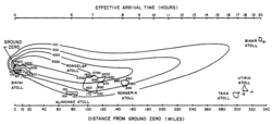
1954年氫彈測試,朗格拉普環礁位於中央
朗格拉普環礁是太平洋由61個島嶼組成的環礁,屬於拉利克礁鏈的一部分,是馬紹爾群島24個立法選區(legislative district)之一,總土地面積21平方公里,中央的潟湖面積2,600平方公里,1998年人口19,鄰近1954年美國氫彈的測試場地。
外部連結
- Marshall Islands site
- Entry at Oceandots.com
- Rongelap Atoll official site
Radio Bikini : Oscar-nominated 1987 documentary on the 1946 atomic bomb tests on Bikini Atoll and the effects on the Bikinians as well as the US sailors who witnessed the tests.
Het Einde van de Wereld The End of the World (1995/VPRO-tv/Theo Uittenbogaard) a Dutch documentary on the history of the people of the island Rongelap, who were evacuated due to fallout from the Bikini nuclear tests and their (inc. John Anjain) hearing by a Senate Committee in Washington DC
|
| ||||||||||||||||||||||||||||

